Vauban's Citadel
West of the centre, a star of bastions and water-filled moats is still in military use. Public woodland and paths surround it and echo its outline, so it stands out sharply on the map.
Minimalist map poster · France
50.6339° N / 3.0551° E
A star-shaped citadel, the canalised Deûle and a dense old town packed close to the Belgian border.

One city, five moods
Tap a style to see it on the wall. Every style costs the same — printed, framed or as HD files.
 Actual pixels · 24 × 36″ print file
Print-sharp
This is a 100% crop of the real print file. Every poster — printed, framed or downloaded — is rendered on our servers at 300 DPI, up to 7,200 × 10,800 pixels, so even the smallest lanes stay crisp on a 24 × 36″ print.
On the wall
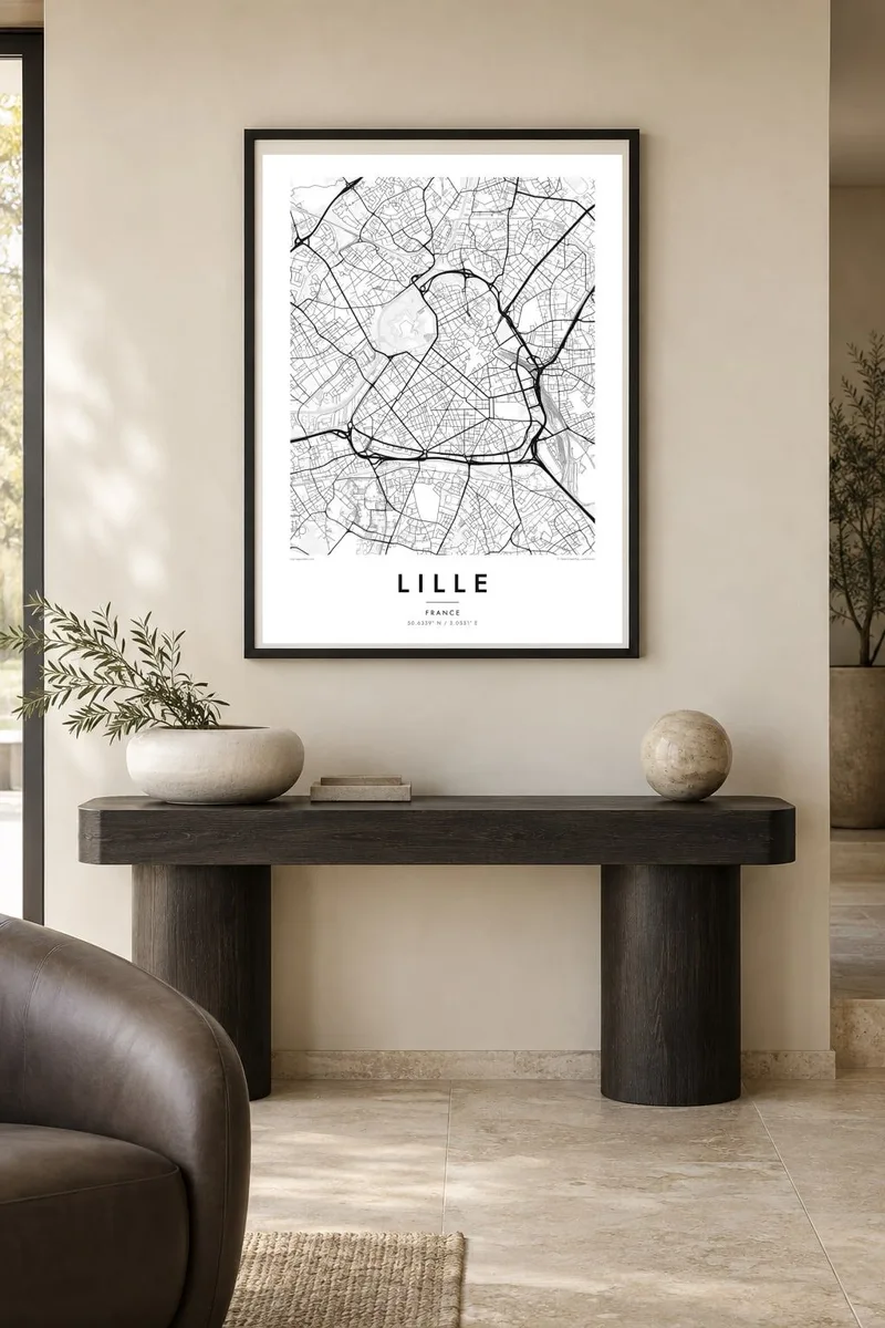


The map
From above, Lille reads as a compact old core wrapped in newer layers. Vieux-Lille packs narrow, bending streets north of the Grand Place, while the Deûle and its canals trace the western edge of the centre. Just beyond them, the Citadel sits inside its bastioned ramparts and moats, one of the clearest geometric shapes on any French city plan.
The citadel was designed by Vauban in the late 1660s, soon after Louis XIV took the city. Its star outline has survived almost intact and earned it the nickname queen of citadels. To the east, the Euralille district and the two main railway stations cut a broad modern corridor. This is where high-speed lines from Paris, London and Brussels meet.
A Lille map poster holds both scales at once: the medieval tangle around the old squares and the long straight boulevards of the nineteenth century, pushing out toward Roubaix and Tourcoing. In black and white, the motorway ring and the wooded ground around the citadel become calm margins for the dense centre, and the canals add a few long, quiet lines of water.
West of the centre, a star of bastions and water-filled moats is still in military use. Public woodland and paths surround it and echo its outline, so it stands out sharply on the map.
North of the Grand Place, lanes curve and branch in irregular patterns. This fine-grained texture contrasts sharply with the straight nineteenth-century boulevards that run south of the old core.
The canalised Deûle and its side channels run along the city's western flank. They link the citadel moats with the old port basins and give the map its only long lines of water.
Make it yours
Add a date, a name or a line of your own, switch style, size or orientation.
The free preview is low-resolution with a watermark. Prints and HD files are rendered at 300 DPI, up to 7,200 × 10,800 px, without a watermark.
Why Lille
Lille suits anyone who studied, worked or changed trains there, or who crossed the border to explore Flanders. The citadel alone makes a striking centrepiece, and the surrounding street pattern rewards a closer look from across the room.
You can add your own title, a subtitle such as a neighbourhood or a date, and the coordinates line. Then choose Classic black & white, Noir, Paper, Blueprint or Sand. Download the HD files for $9 or order a printed poster with an optional wooden frame.
Order the Lille poster| Print size | Resolution | Files |
|---|---|---|
| 30 × 40 cm11.8 × 15.7″ | 3,543 × 4,724 px | PNG · PDF |
| 29.7 × 42 cm (A3)11.7 × 16.5″ | 3,508 × 4,961 px | PNG · PDF |
| 42 × 59.4 cm (A2)16.5 × 23.4″ | 4,961 × 7,016 px | PNG · PDF |
| 45.7 × 61 cm18 × 24″ | 5,400 × 7,200 px | PNG · PDF |
| 50 × 70 cm19.7 × 27.6″ | 5,906 × 8,268 px | PNG · PDF |
| 61 × 91.4 cm24 × 36″ | 7,200 × 10,800 px | PNG · PDF |
For comparison, the free preview is 900 px wide, watermarked and meant for screens. The HD files have up to 8× the resolution in each direction and print cleanly at full poster size.
Pick a style at the top of the page, then choose Printed Poster — a size and, if you like, a frame — or Digital HD Files. Checkout takes one step, and your order page updates as soon as the payment goes through.
It is printed on premium 200 gsm matte paper in one of six sizes, from 30 × 40 cm to 24 × 36″. Printed posters start at $39, shipping included.
Yes. Choose a solid wood frame in black, white, natural oak or dark wood. It comes with shatterproof glazing and is ready to hang. Framed posters start at $99, shipping included.
Shipping is free to 60+ countries. Each poster is printed by the nearest of our print partners in 30+ countries and usually arrives in 3–7 business days. You can follow the status and tracking under My Orders. A few countries take 2–5 weeks, and where we don't ship yet, the site tells you before you pay.
Send us a photo within 14 days of delivery and we will reprint it for free or refund you.
Yes. In the editor on this page, change the title, the subtitle and the coordinates line to anything you like, and pick a style and size. Printed, framed and digital orders all use exactly your design.
For $9 you get 300 DPI PNG and print-ready PDF files in all six sizes, without a watermark, to print anywhere. Not sure yet? Download a free watermarked preview first.
Nearby
