Blue Water Bridge
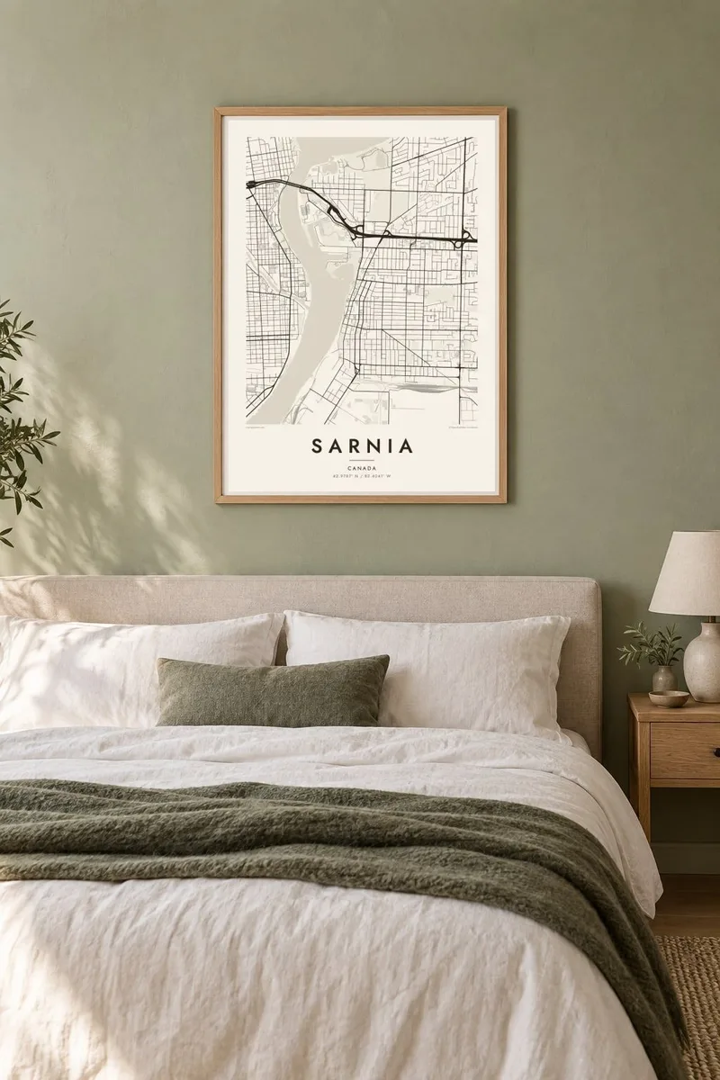
Two parallel spans leap the St. Clair River exactly where Lake Huron empties into it, linking Sarnia with Port Huron. On the poster they form a crisp double line across the water.
Minimalist map poster · Canada
42.9787° N / 82.4041° W
A corner city where Lake Huron narrows into the St. Clair River, facing Michigan across a thin strip of water.

One city, five moods
Tap a style to see it on the wall. Every style costs the same — printed, framed or as HD files.
 Actual pixels · 24 × 36″ print file
Print-sharp
This is a 100% crop of the real print file. Every poster — printed, framed or downloaded — is rendered on our servers at 300 DPI, up to 7,200 × 10,800 pixels, so even the smallest lanes stay crisp on a 24 × 36″ print.
On the wall


The map
Sarnia occupies the southern tip of Lake Huron, where the broad lake funnels into the St. Clair River. This gives the city an unusual corner position on the map: a straight lakeshore running north, a river edge running south, and a mostly regular street grid filling the land between. Port Huron, Michigan lies across the narrow channel, so the international border runs just offshore.
The Blue Water Bridge is the most recognisable structure in the frame. Its twin spans cross the river right at the lake outlet, and it is one of the busiest crossings between Canada and the United States. Further south along the river, the street grid gives way to the large, blocky footprints of the petrochemical plants known locally as Chemical Valley, a very different texture from the homes inland.
Parks line much of the waterfront, Canatara Park on the lake among them, and the shoreline's clean, gently curving edge prints well in monochrome. A Sarnia map poster captures this meeting of lake, river and border in one view, from the compact downtown blocks by the water to the suburban loops spreading east and south.
Two parallel spans leap the St. Clair River exactly where Lake Huron empties into it, linking Sarnia with Port Huron. On the poster they form a crisp double line across the water.
A narrow, fast-flowing channel forms the city's western edge and the national border. Its straight banks give the map a strong vertical axis on one side.
North of the bridge the land opens onto the lake, with beaches and parkland along a smooth curve. The empty expanse of water leaves the composition plenty of breathing room.
Make it yours
Add a date, a name or a line of your own, switch style, size or orientation.
The free preview is low-resolution with a watermark. Prints and HD files are rendered at 300 DPI, up to 7,200 × 10,800 px, without a watermark.
Why Sarnia
Sarnia's geography is easy to read and hard to forget: a lake, a river and a bridge to another country, all within a few kilometres. For anyone who grew up near the water or crossed that bridge often, the map works as a clear, honest portrait of the place.
Add your own title, a subtitle or date, and adjust the coordinates line. Pick from five styles: Classic black & white, Noir, Paper, Blueprint and Sand. HD files for six print sizes cost $9, and printed posters with an optional wooden frame are also available.
Order the Sarnia poster| Print size | Resolution | Files |
|---|---|---|
| 30 × 40 cm11.8 × 15.7″ | 3,543 × 4,724 px | PNG · PDF |
| 29.7 × 42 cm (A3)11.7 × 16.5″ | 3,508 × 4,961 px | PNG · PDF |
| 42 × 59.4 cm (A2)16.5 × 23.4″ | 4,961 × 7,016 px | PNG · PDF |
| 45.7 × 61 cm18 × 24″ | 5,400 × 7,200 px | PNG · PDF |
| 50 × 70 cm19.7 × 27.6″ | 5,906 × 8,268 px | PNG · PDF |
| 61 × 91.4 cm24 × 36″ | 7,200 × 10,800 px | PNG · PDF |
For comparison, the free preview is 900 px wide, watermarked and meant for screens. The HD files have up to 8× the resolution in each direction and print cleanly at full poster size.
Pick a style at the top of the page, then choose Printed Poster — a size and, if you like, a frame — or Digital HD Files. Checkout takes one step, and your order page updates as soon as the payment goes through.
It is printed on premium 200 gsm matte paper in one of six sizes, from 30 × 40 cm to 24 × 36″. Printed posters start at $39, shipping included.
Yes. Choose a solid wood frame in black, white, natural oak or dark wood. It comes with shatterproof glazing and is ready to hang. Framed posters start at $99, shipping included.
Shipping is free to 60+ countries. Each poster is printed by the nearest of our print partners in 30+ countries and usually arrives in 3–7 business days. You can follow the status and tracking under My Orders. A few countries take 2–5 weeks, and where we don't ship yet, the site tells you before you pay.
Send us a photo within 14 days of delivery and we will reprint it for free or refund you.
Yes. In the editor on this page, change the title, the subtitle and the coordinates line to anything you like, and pick a style and size. Printed, framed and digital orders all use exactly your design.
For $9 you get 300 DPI PNG and print-ready PDF files in all six sizes, without a watermark, to print anywhere. Not sure yet? Download a free watermarked preview first.
Nearby
