Hooghly waterfront
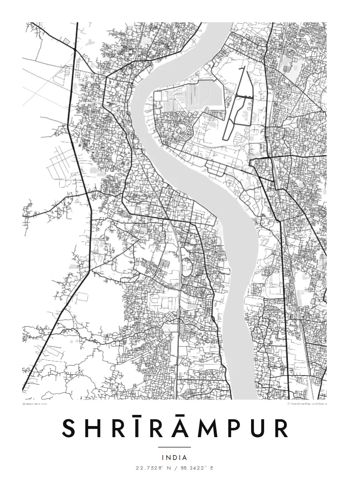
The river forms the eastern edge of the town, a wide pale band on the poster. Ghats and lanes meet it at regular intervals along the bank.
Minimalist map poster · India
22.7528° N / 88.3422° E
A long riverside town on the west bank of the Hooghly, its old Danish quarter facing Barrackpore across the water.
One city, five moods
Tap a style to see it on the wall. Every style costs the same — printed, framed or as HD files.
 Actual pixels · 24 × 36″ print file
Print-sharp
This is a 100% crop of the real print file. Every poster — printed, framed or downloaded — is rendered on our servers at 300 DPI, up to 7,200 × 10,800 pixels, so even the smallest lanes stay crisp on a 24 × 36″ print.
On the wall


The map
Shrīrāmpur stretches along the western bank of the Hooghly River, north of Kolkata, and the river defines its map. The town is a narrow ribbon between the water and the railway line that runs parallel to it inland, with lanes leading down to ghats on the riverfront. On the opposite bank lies Barrackpore, and the broad band of the river separates the two like a wide avenue.
From 1755 to 1845 the town was a Danish trading settlement called Frederiksnagore, and traces of that period remain, including St Olav's Church and the old Government House. Serampore College, founded in 1818 by the missionaries William Carey, Joshua Marshman and William Ward, stands by the river and is among the oldest colleges in India.
A Shrīrāmpur map poster frames the relationship between town and river: the dense lanes along the bank, the straight rail line inland, and the empty width of the Hooghly with its gentle bends. It is a map about edges and crossings, a reminder of the town's long role as a port, a college town and a quiet neighbour to Kolkata.
The river forms the eastern edge of the town, a wide pale band on the poster. Ghats and lanes meet it at regular intervals along the bank.
Near the riverfront, the older core from the Danish period, with its church and former Government House, sits among a tighter pattern of streets than the newer districts inland.
Serampore College occupies a riverside site, a larger open plot among the lanes that recalls the town's long history as a centre of learning and printing.
Make it yours
Add a date, a name or a line of your own, switch style, size or orientation.
The free preview is low-resolution with a watermark. Prints and HD files are rendered at 300 DPI, up to 7,200 × 10,800 px, without a watermark.
Why Shrīrāmpur
Shrīrāmpur has deep roots for Bengali families, for alumni of its college and for anyone interested in the colonial history of the Hooghly settlements. A map of the riverbank makes a thoughtful gift and sits well in a study or reading room.
Add a name, an alumni year or a family address to the title and subtitle, and choose one of five styles, from the warm Paper and Sand to the crisp Classic black & white, Noir and Blueprint. Order it printed on matte paper or download the HD files.
Order the Shrīrāmpur poster| Print size | Resolution | Files |
|---|---|---|
| 30 × 40 cm11.8 × 15.7″ | 3,543 × 4,724 px | PNG · PDF |
| 29.7 × 42 cm (A3)11.7 × 16.5″ | 3,508 × 4,961 px | PNG · PDF |
| 42 × 59.4 cm (A2)16.5 × 23.4″ | 4,961 × 7,016 px | PNG · PDF |
| 45.7 × 61 cm18 × 24″ | 5,400 × 7,200 px | PNG · PDF |
| 50 × 70 cm19.7 × 27.6″ | 5,906 × 8,268 px | PNG · PDF |
| 61 × 91.4 cm24 × 36″ | 7,200 × 10,800 px | PNG · PDF |
For comparison, the free preview is 900 px wide, watermarked and meant for screens. The HD files have up to 8× the resolution in each direction and print cleanly at full poster size.
Pick a style at the top of the page, then choose Printed Poster — a size and, if you like, a frame — or Digital HD Files. Checkout takes one step, and your order page updates as soon as the payment goes through.
It is printed on premium 200 gsm matte paper in one of six sizes, from 30 × 40 cm to 24 × 36″. Printed posters start at $39, shipping included.
Yes. Choose a solid wood frame in black, white, natural oak or dark wood. It comes with shatterproof glazing and is ready to hang. Framed posters start at $99, shipping included.
Shipping is free to 60+ countries. Each poster is printed by the nearest of our print partners in 30+ countries and usually arrives in 3–7 business days. You can follow the status and tracking under My Orders. A few countries take 2–5 weeks, and where we don't ship yet, the site tells you before you pay.
Send us a photo within 14 days of delivery and we will reprint it for free or refund you.
Yes. In the editor on this page, change the title, the subtitle and the coordinates line to anything you like, and pick a style and size. Printed, framed and digital orders all use exactly your design.
For $9 you get 300 DPI PNG and print-ready PDF files in all six sizes, without a watermark, to print anywhere. Not sure yet? Download a free watermarked preview first.
Nearby
