Hilly terrain
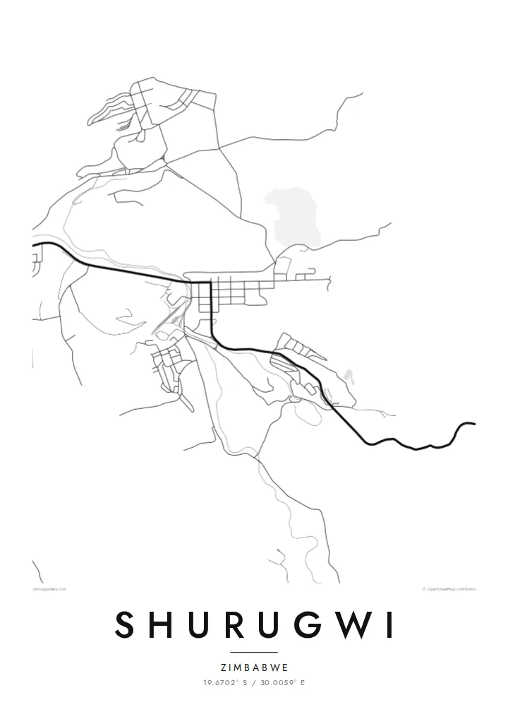
Ridges and valleys surround the town and bend its roads into long curves. The relief comes through clearly even in a plain line drawing.
Minimalist map poster · Zimbabwe
19.6702° S / 30.0059° E
A mining town in the hills of Zimbabwe's Midlands, where the old Great Dyke workings shape roads that twist between ridges.
One city, five moods
Tap a style to see it on the wall. Every style costs the same — printed, framed or as HD files.
 Actual pixels · 24 × 36″ print file
Print-sharp
This is a 100% crop of the real print file. Every poster — printed, framed or downloaded — is rendered on our servers at 300 DPI, up to 7,200 × 10,800 pixels, so even the smallest lanes stay crisp on a 24 × 36″ print.
On the wall


The map
Shurugwi, formerly called Selukwe, lies in the Midlands Province of Zimbabwe, south of Gweru. Unlike the flat plateau towns nearby, it sits among hills, and on a map the relief shows immediately. Roads curve around ridges and follow the valleys, and the town spreads unevenly, dense in some places and open in others, according to the terrain.
The town grew with mining. Gold was worked here early, and the area sits on the Great Dyke, the long mineral-rich geological formation that runs across Zimbabwe and is known especially for chrome. A Shurugwi map poster captures the imprint of that history: settlements laid out near the mines and access roads winding into the hills toward the workings.
The central area has a more regular street grid, a reminder of its early planning, while outlying suburbs and townships follow their own patterns. Beyond the town the hills are covered with scrub and woodland. In black and white the contrast between the planned centre and the winding roads over rough ground gives the map a lot of character.
Ridges and valleys surround the town and bend its roads into long curves. The relief comes through clearly even in a plain line drawing.
Roads lead out to old and active mine areas linked to gold and the chrome deposits of the Great Dyke, marking the town's economic origins.
A more regular grid at the core contrasts with the winding outer roads, showing the town's early planning within its rugged setting.
Make it yours
Add a date, a name or a line of your own, switch style, size or orientation.
The free preview is low-resolution with a watermark. Prints and HD files are rendered at 300 DPI, up to 7,200 × 10,800 px, without a watermark.
Why Shurugwi
A map of Shurugwi suits people who grew up among its hills, worked in the mines, or keep family ties to the Midlands. It is a meaningful gift for relatives in Harare, Johannesburg or London.
Choose the title and subtitle, perhaps with the old or new name, and the coordinates, then select Classic black & white, Noir, Paper, Blueprint or Sand. The download is $9 for six sizes as 300 DPI PNG and PDF, with no watermark.
Order the Shurugwi poster| Print size | Resolution | Files |
|---|---|---|
| 30 × 40 cm11.8 × 15.7″ | 3,543 × 4,724 px | PNG · PDF |
| 29.7 × 42 cm (A3)11.7 × 16.5″ | 3,508 × 4,961 px | PNG · PDF |
| 42 × 59.4 cm (A2)16.5 × 23.4″ | 4,961 × 7,016 px | PNG · PDF |
| 45.7 × 61 cm18 × 24″ | 5,400 × 7,200 px | PNG · PDF |
| 50 × 70 cm19.7 × 27.6″ | 5,906 × 8,268 px | PNG · PDF |
| 61 × 91.4 cm24 × 36″ | 7,200 × 10,800 px | PNG · PDF |
For comparison, the free preview is 900 px wide, watermarked and meant for screens. The HD files have up to 8× the resolution in each direction and print cleanly at full poster size.
Pick a style at the top of the page, then choose Printed Poster — a size and, if you like, a frame — or Digital HD Files. Checkout takes one step, and your order page updates as soon as the payment goes through.
It is printed on premium 200 gsm matte paper in one of six sizes, from 30 × 40 cm to 24 × 36″. Printed posters start at $39, shipping included.
Yes. Choose a solid wood frame in black, white, natural oak or dark wood. It comes with shatterproof glazing and is ready to hang. Framed posters start at $99, shipping included.
Shipping is free to 60+ countries. Each poster is printed by the nearest of our print partners in 30+ countries and usually arrives in 3–7 business days. You can follow the status and tracking under My Orders. A few countries take 2–5 weeks, and where we don't ship yet, the site tells you before you pay.
Send us a photo within 14 days of delivery and we will reprint it for free or refund you.
Yes. In the editor on this page, change the title, the subtitle and the coordinates line to anything you like, and pick a style and size. Printed, framed and digital orders all use exactly your design.
For $9 you get 300 DPI PNG and print-ready PDF files in all six sizes, without a watermark, to print anywhere. Not sure yet? Download a free watermarked preview first.
Nearby
