Compact island streets
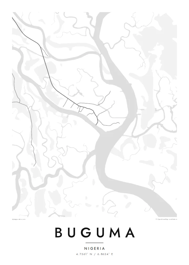
Short blocks fill the available dry ground densely, forming a tight pattern of streets that ends sharply where the land meets water.
Ata mapa faigafua · Nigeria
4.7361° N / 6.8624° E
A Kalabari island town in the Niger Delta, its streets drawn tight on dry land between creeks and mangrove.


Kolo e tahi, lanu e nima
Tuki he sitaili ke sio ai ʻi te holo. ʻE tatau pē te totogi ʻo te sitaili fuli pē — mokā tā, fakakātoa, peʻe ko he ʻu faila HD.
 Ngaahi pikiseli moʻoni · faila tā 24 × 36″
Mahino lelei ki te pulūti
Ko he konga 100% ʻo te faila tā moʻoni ʻaeni. Ko te ʻu posita fuli pē — mokā tā, fakakātoa peʻe download — ʻe fakatupu ʻi ʻomātou seva ʻi te 300 DPI, aʻu ki te 7,200 × 10,800 pikiseli, koia ʻe nofo mahino ai te ʻu ala liliki ʻi he tā 24 × 36″.
ʻI Te Puipui


Te mapa
Buguma is a town in Rivers State, in the eastern Niger Delta, and the headquarters of Asari-Toru Local Government Area. It is also the seat of the Amanyanabo, the traditional ruler of the Kalabari kingdom. On a map, water is everywhere: the town occupies a patch of firm ground surrounded by tidal creeks and wide stretches of mangrove swamp.
Because dry land is limited, the streets are drawn close together in a compact grid of short blocks that stops abruptly at the waterline. Around it, creeks branch and rejoin in intricate patterns, and for many journeys boats matter as much as roads. The contrast between the dense town and the wandering channels is what makes the map so distinctive.
A Buguma map poster suits Kalabari families at home and in the diaspora, and anyone with ties to the delta. The design shows a town held within water: clear lines of streets at the centre, thin branching creeks around it, and the pale expanse of mangrove beyond. It is a quiet, graphic image of a very particular place.
Short blocks fill the available dry ground densely, forming a tight pattern of streets that ends sharply where the land meets water.
Branching creeks wind around the town and through the surrounding delta, drawing fine curving lines that give the poster much of its character.
Beyond the creeks, wide areas of mangrove swamp remain largely unbuilt, leaving calm open space that frames the town like a margin.
Faʻu ke ʻau ʻa ʻau
Tuku he ʻaho, he hingoa peʻe he kiʻi palalau ʻa ʻau, fetogi te faʻahiga, te lahi peʻe te hake.
Ko te faʻata fua noa ʻe māʻulalo hono lelei pea ʻe ʻi ai he fakaʻilonga. Ko te ʻu tā mo te ʻu faila HD ʻe fakatupu ʻi te 300 DPI, aʻu ki te 7,200 × 10,800 px, ʻe mole ʻi ai he fakaʻilonga.
Koteā ko Buguma
For Kalabari people, Buguma carries family history, festivals and the authority of the kingdom's traditional seat. A map of it makes a meaningful gift, with a title in your own words, a family name, or a date recorded in the subtitle and coordinates line.
The creeks look striking in Blueprint and Noir, and Classic black & white, Paper and Sand suit quieter rooms. Download the $9 HD files in six print sizes with no watermark, or order a matte printed poster shipped from a print partner.
Fakatau te posita Buguma| Lahi ʻo te pulūti | Mahino | Faile |
|---|---|---|
| 30 × 40 cm (11.8 × 15.7″) | 3,543 × 4,724 px | PNG · PDF |
| 29.7 × 42 cm (A3, 11.7 × 16.5″) | 3,508 × 4,961 px | PNG · PDF |
| 42 × 59.4 cm (A2, 16.5 × 23.4″) | 4,961 × 7,016 px | PNG · PDF |
| 45.7 × 61 cm (18 × 24″) | 5,400 × 7,200 px | PNG · PDF |
| 50 × 70 cm (19.7 × 27.6″) | 5,906 × 8,268 px | PNG · PDF |
| 61 × 91.4 cm (24 × 36″) | 7,200 × 10,800 px | PNG · PDF |
Ko te ata ʻe mole totogi ʻe 900 px tona laulahi, mo te fakaʻilonga, ki te sioʻata pē. Ko te ʻu faile HD ʻe aʻu ki te liuga 8 tona mahino, pea ʻe pulūti lelei ʻi te lahi kātoa.
Fili he sitaili ʻi te tuʻa ʻo te pasina, pea fili leva te Posita Tā — he lahi pea, kapau ʻe ke loto ai, he fakakātoa — peʻe ko te ʻu Faila HD Fakakomipiuta. ʻE tahi pē te sitepu ʻo te totogi, pea ʻe fakafou fakavavevave pē tau pasina fakatau mai te taimi ʻe fai ai te totogi.
ʻE tā ʻi he pepa lelei ʻaupito 200 gsm matte, ʻi he tahi ʻo te ono lahi, mai te 30 × 40 cm ki te 24 × 36″. ʻE kamata te ʻu posita tā ʻi te {printFrom}, kātoa mo te ʻave.
ʻIo. Fili he fakakātoa ʻakau moʻoni ʻi te kili, hinahina, ʻakau natula peʻe ʻakau ʻuliʻuli. ʻE ʻi ai mo he sioga mālohi ʻe mole mafesi, pea kua teu ke tautau. ʻE kamata te ʻu posita fakakātoa ʻi te {framedFrom}, kātoa mo te ʻave.
Ko te ʻave ʻe tuʻa totogi ʻi te malamanei katoa. Ko te pōsita ʻe tā e te kaumeʻa tā ʻoku ofi taha ʻi fenua e 30+, pea ʻe aʻu mai ʻi ʻaho gāue e 3–7. ʻE lava ke ke sivi te tuʻunga mo te tulitaki ʻi lalo ʻo Aku ʻōta. ʻE ʻi ai ni fenua ʻe uike e 2–5, pea ʻi te ʻu fenua ʻe mole te ʻave ki ai, ʻe fakahā e te sitē ʻi muʻa ʻo te totogi.
Fekau mai he ʻata ʻi loto ʻi te ʻaho e 14 talu mai te aʻu mai, pea mātou toe tā noa peʻe toe totogi atu.
ʻIo. ʻI te meʻa fakatonutonu ʻi te pasina ʻaeni, fetogi te kupu tāfito, te kupu lalo pea mo te laina koʻoliteti ki he meʻa fuli pē ʻe ke loto ai, pea fili he sitaili mo he lahi. Ko te ʻu fakatau tā, fakakātoa mo fakakomipiuta ʻe fakaʻaogaʻi katoa pē tou fakatātā.
Mo te $9 ʻe ke maʻu ai te ʻu faila PNG 300 DPI mo PDF kua teu ke tā, ʻi te ono lahi kātoa, ʻe mole ʻi ai he fakaʻilonga, ke ke tā ai ʻi soʻo he potu. Kei tā fakafiafia? Download muʻa he faʻata mokā mo he fakaʻilonga, ʻe fua noa.
