Cap-Vert peninsula
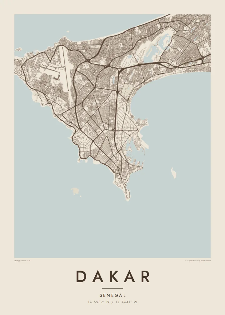
The city fills a hooked peninsula, with ocean on three sides and the mainland to the east, creating a strong, compact silhouette on the page.
Ata mapa faigafua · Senegal
14.6937° N / 17.4441° W
A city at the tip of a peninsula reaching into the Atlantic, the westernmost point of mainland Africa.


Kolo e tahi, lanu e nima
Tuki he sitaili ke sio ai ʻi te holo. ʻE tatau pē te totogi ʻo te sitaili fuli pē — mokā tā, fakakātoa, peʻe ko he ʻu faila HD.
 Ngaahi pikiseli moʻoni · faila tā 24 × 36″
Mahino lelei ki te pulūti
Ko he konga 100% ʻo te faila tā moʻoni ʻaeni. Ko te ʻu posita fuli pē — mokā tā, fakakātoa peʻe download — ʻe fakatupu ʻi ʻomātou seva ʻi te 300 DPI, aʻu ki te 7,200 × 10,800 pikiseli, koia ʻe nofo mahino ai te ʻu ala liliki ʻi he tā 24 × 36″.
ʻI Te Puipui


Te mapa
Dakar occupies the Cap-Vert peninsula, which pushes out into the Atlantic from the coast of Senegal. At its western end, the Pointe des Almadies is the westernmost point of the African mainland. On a map the city is almost surrounded by water, with the open ocean along the north and west and a sheltered bay and harbour to the south and east.
The historic centre, known as the Plateau, sits on the southern tip, with a regular colonial-era street grid, the port and the main government buildings. From there, the city extends north and west across the peninsula in a mix of planned districts and older neighbourhoods, and coastal roads follow the cliffs and beaches around the edges.
Near the western shore rise the two Mamelles hills, one topped by a lighthouse and the other by the African Renaissance Monument. Offshore lies the small island of Gorée, a UNESCO site associated with the Atlantic slave trade. A Dakar map poster includes that scatter of islands and headlands, which gives the city one of the most recognisable outlines in West Africa.
The city fills a hooked peninsula, with ocean on three sides and the mainland to the east, creating a strong, compact silhouette on the page.
At the southern tip, a tight grid of streets marks the old centre and administrative quarter, set right beside the port and the sheltered harbour.
Small islands sit off the coast, Gorée to the southeast near the harbour and Ngor off the western tip, adding details that frame the peninsula.
Faʻu ke ʻau ʻa ʻau
Tuku he ʻaho, he hingoa peʻe he kiʻi palalau ʻa ʻau, fetogi te faʻahiga, te lahi peʻe te hake.
Ko te faʻata fua noa ʻe māʻulalo hono lelei pea ʻe ʻi ai he fakaʻilonga. Ko te ʻu tā mo te ʻu faila HD ʻe fakatupu ʻi te 300 DPI, aʻu ki te 7,200 × 10,800 px, ʻe mole ʻi ai he fakaʻilonga.
Koteā ko Dakar
Dakar is a place people leave and return to, whether for work, family or study, and its peninsula shape is instantly recognisable. A map of the city holds the coastline, the Plateau and the islands in a single calm image.
Make it personal with a title, a subtitle and your own coordinates, perhaps naming a quarter or a date. Five styles are available, including Paper and Sand for warmer rooms, and the HD download covers six print sizes as 300 DPI PNG and PDF files.
Fakatau te posita Dakar| Lahi ʻo te pulūti | Mahino | Faile |
|---|---|---|
| 30 × 40 cm (11.8 × 15.7″) | 3,543 × 4,724 px | PNG · PDF |
| 29.7 × 42 cm (A3, 11.7 × 16.5″) | 3,508 × 4,961 px | PNG · PDF |
| 42 × 59.4 cm (A2, 16.5 × 23.4″) | 4,961 × 7,016 px | PNG · PDF |
| 45.7 × 61 cm (18 × 24″) | 5,400 × 7,200 px | PNG · PDF |
| 50 × 70 cm (19.7 × 27.6″) | 5,906 × 8,268 px | PNG · PDF |
| 61 × 91.4 cm (24 × 36″) | 7,200 × 10,800 px | PNG · PDF |
Ko te ata ʻe mole totogi ʻe 900 px tona laulahi, mo te fakaʻilonga, ki te sioʻata pē. Ko te ʻu faile HD ʻe aʻu ki te liuga 8 tona mahino, pea ʻe pulūti lelei ʻi te lahi kātoa.
Fili he sitaili ʻi te tuʻa ʻo te pasina, pea fili leva te Posita Tā — he lahi pea, kapau ʻe ke loto ai, he fakakātoa — peʻe ko te ʻu Faila HD Fakakomipiuta. ʻE tahi pē te sitepu ʻo te totogi, pea ʻe fakafou fakavavevave pē tau pasina fakatau mai te taimi ʻe fai ai te totogi.
ʻE tā ʻi he pepa lelei ʻaupito 200 gsm matte, ʻi he tahi ʻo te ono lahi, mai te 30 × 40 cm ki te 24 × 36″. ʻE kamata te ʻu posita tā ʻi te $39, kātoa mo te ʻave.
ʻIo. Fili he fakakātoa ʻakau moʻoni ʻi te kili, hinahina, ʻakau natula peʻe ʻakau ʻuliʻuli. ʻE ʻi ai mo he sioga mālohi ʻe mole mafesi, pea kua teu ke tautau. ʻE kamata te ʻu posita fakakātoa ʻi te $99, kātoa mo te ʻave.
Ko te ʻave ʻe tuʻa totogi ʻi te malamanei katoa. Ko te pōsita ʻe tā e te kaumeʻa tā ʻoku ofi taha ʻi fenua e 30+, pea ʻe aʻu mai ʻi ʻaho gāue e 3–7. ʻE lava ke ke sivi te tuʻunga mo te tulitaki ʻi lalo ʻo Aku ʻōta. ʻE ʻi ai ni fenua ʻe uike e 2–5, pea ʻi te ʻu fenua ʻe mole te ʻave ki ai, ʻe fakahā e te sitē ʻi muʻa ʻo te totogi.
Fekau mai he ʻata ʻi loto ʻi te ʻaho e 14 talu mai te aʻu mai, pea mātou toe tā noa peʻe toe totogi atu.
ʻIo. ʻI te meʻa fakatonutonu ʻi te pasina ʻaeni, fetogi te kupu tāfito, te kupu lalo pea mo te laina koʻoliteti ki he meʻa fuli pē ʻe ke loto ai, pea fili he sitaili mo he lahi. Ko te ʻu fakatau tā, fakakātoa mo fakakomipiuta ʻe fakaʻaogaʻi katoa pē tou fakatātā.
Mo te $9 ʻe ke maʻu ai te ʻu faila PNG 300 DPI mo PDF kua teu ke tā, ʻi te ono lahi kātoa, ʻe mole ʻi ai he fakaʻilonga, ke ke tā ai ʻi soʻo he potu. Kei tā fakafiafia? Download muʻa he faʻata mokā mo he fakaʻilonga, ʻe fua noa.
