The caldera
The flooded centre of the old volcano forms a broad open space inside the crescent. It is bordered by cliffs that fall steeply into the sea.
Minimalist map poster · Greece
36.4072° N / 25.4209° E
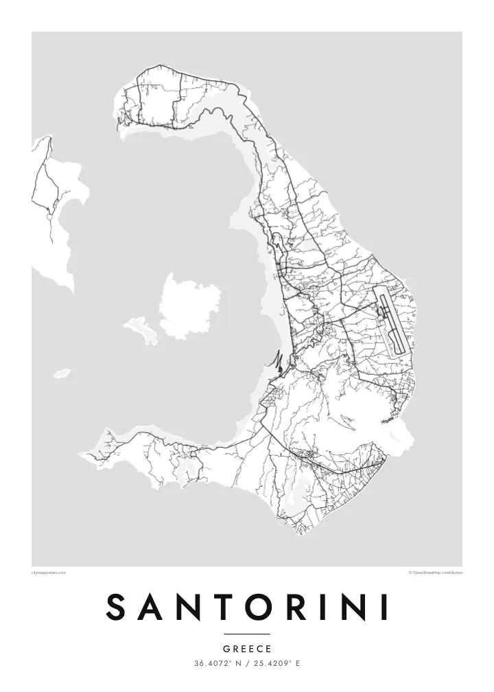
A crescent of land around a flooded volcanic caldera, with a young volcanic island rising in the middle.
One city, five moods
Tap a style to see it on the wall. Every style costs the same — printed, framed or as HD files.
 Actual pixels · 24 × 36″ print file
Print-sharp
This is a 100% crop of the real print file. Every poster — printed, framed or downloaded — is rendered on our servers at 300 DPI, up to 7,200 × 10,800 pixels, so even the smallest lanes stay crisp on a 24 × 36″ print.
On the wall


The island
Santorini is the remaining rim of a volcano. From above, the main island forms a crescent that wraps around a large, flooded caldera, with Therasia and a smaller islet completing the ring to the west. In the centre of the water sits Nea Kameni, a dark, young volcanic island that formed in eruptions over the past few centuries.
The inner edge of the crescent is a steep cliff, and the island's best-known villages cling to its top. Fira, the main town, and Oia at the northern tip are dense clusters of lanes and stairways overlooking the caldera. The outer side slopes gently to the east and south, towards farmland, vineyards and long dark beaches. The airport and most of the roads are on this side.
A Santorini map poster captures one of the most dramatic outlines in the Mediterranean. The Bronze Age eruption that shaped much of the caldera buried the settlement at Akrotiri, on the southern tip, and preserved its buildings and wall paintings under ash. On the map, the curve of the island and the empty water inside it make a striking composition in black and white.
The flooded centre of the old volcano forms a broad open space inside the crescent. It is bordered by cliffs that fall steeply into the sea.
A young volcanic island in the middle of the caldera, formed by eruptions over recent centuries. It appears as a dark, compact shape in the empty water.
Tight networks of lanes and steps run along the rim of the cliff. From above they look like fine lines tracing the inner edge of the island.
Make it yours
Add a date, a name or a line of your own, switch style, size or orientation.
The free preview is low-resolution with a watermark. Prints and HD files are rendered at 300 DPI, up to 7,200 × 10,800 px, without a watermark.
Why Santorini
Santorini is where many people get married, spend a honeymoon or watch a sunset they still talk about. The crescent and caldera make an image that is instantly recognisable, and a monochrome print keeps it graphic rather than postcard-like.
Add names and a date to the title and subtitle, or set the coordinates to a particular terrace in Oia or Fira. Choose from Classic black & white, Noir, Paper, Blueprint or Sand.
Order the Santorini poster| Print size | Resolution | Files |
|---|---|---|
| 30 × 40 cm11.8 × 15.7″ | 3,543 × 4,724 px | PNG · PDF |
| 29.7 × 42 cm (A3)11.7 × 16.5″ | 3,508 × 4,961 px | PNG · PDF |
| 42 × 59.4 cm (A2)16.5 × 23.4″ | 4,961 × 7,016 px | PNG · PDF |
| 45.7 × 61 cm18 × 24″ | 5,400 × 7,200 px | PNG · PDF |
| 50 × 70 cm19.7 × 27.6″ | 5,906 × 8,268 px | PNG · PDF |
| 61 × 91.4 cm24 × 36″ | 7,200 × 10,800 px | PNG · PDF |
For comparison, the free preview is 900 px wide, watermarked and meant for screens. The HD files have up to 8× the resolution in each direction and print cleanly at full poster size.
Pick a style at the top of the page, then choose Printed Poster — a size and, if you like, a frame — or Digital HD Files. Checkout takes one step, and your order page updates as soon as the payment goes through.
It is printed on premium 200 gsm matte paper in one of six sizes, from 30 × 40 cm to 24 × 36″. Printed posters start at $39, shipping included.
Yes. Choose a solid wood frame in black, white, natural oak or dark wood. It comes with shatterproof glazing and is ready to hang. Framed posters start at $99, shipping included.
Shipping is free to 60+ countries. Each poster is printed by the nearest of our print partners in 30+ countries and usually arrives in 3–7 business days. You can follow the status and tracking under My Orders. A few countries take 2–5 weeks, and where we don't ship yet, the site tells you before you pay.
Send us a photo within 14 days of delivery and we will reprint it for free or refund you.
Yes. In the editor on this page, change the title, the subtitle and the coordinates line to anything you like, and pick a style and size. Printed, framed and digital orders all use exactly your design.
For $9 you get 300 DPI PNG and print-ready PDF files in all six sizes, without a watermark, to print anywhere. Not sure yet? Download a free watermarked preview first.
Nearby
