River Leie
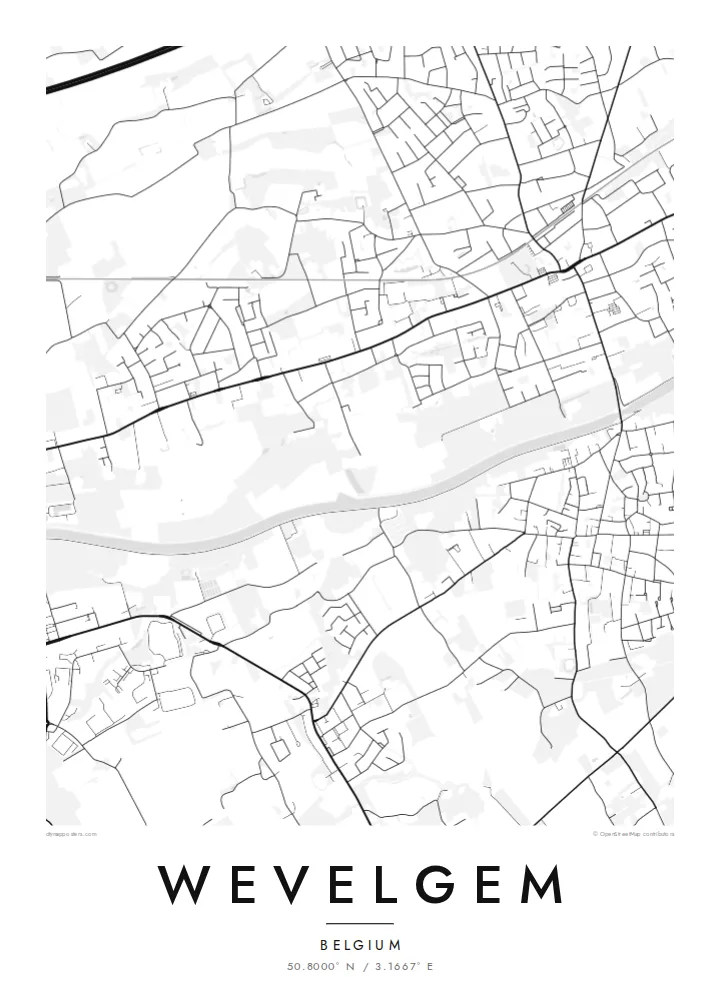
The Leie runs along the southern side of Wevelgem, a gentle curve on the map that has shaped local industry and connects the town to Kortrijk and Menen.
Minimalist map poster · Belgium
50.8000° N / 3.1667° E
A Flemish town on the Leie, with three village cores, a regional airfield and roads threading through dense West Flanders
One city, five moods
Tap a style to see it on the wall. Every style costs the same — printed, framed or as HD files.
 Actual pixels · 24 × 36″ print file
Print-sharp
This is a 100% crop of the real print file. Every poster — printed, framed or downloaded — is rendered on our servers at 300 DPI, up to 7,200 × 10,800 pixels, so even the smallest lanes stay crisp on a 24 × 36″ print.
On the wall


The map
Wevelgem lies in West Flanders, just west of Kortrijk, with the river Leie forming its southern edge and the French border not far away. The municipality brings together Wevelgem itself with Gullegem and Moorsele, and the map shows three distinct village centres linked by roads through a landscape of houses, workshops and fields.
One of the clearest shapes on the map is the runway of Kortrijk-Wevelgem Airport, a long straight line among the smaller plots. The Leie curves along the south, its banks lined with industry and towpaths, a reminder of the river's long role in the region's flax and textile trade. Motorways and railway lines add bolder strokes across the finer street grid.
Cycling fans know the name from Gent–Wevelgem, the spring classic that finishes here after crossing the hills of the Flemish-French border. A Wevelgem map poster captures the town behind that finish line: a mix of compact centres, ribbon development along roads, and the river and runway as its strongest features.
The Leie runs along the southern side of Wevelgem, a gentle curve on the map that has shaped local industry and connects the town to Kortrijk and Menen.
Kortrijk-Wevelgem Airport's runway cuts a long, clean line through the municipality, one of the few perfectly straight shapes in the Flemish landscape.
Wevelgem, Gullegem and Moorsele each have their own centre, visible as denser knots of streets joined by roads lined with houses.
Make it yours
Add a date, a name or a line of your own, switch style, size or orientation.
The free preview is low-resolution with a watermark. Prints and HD files are rendered at 300 DPI, up to 7,200 × 10,800 px, without a watermark.
Why Wevelgem
Wevelgem suits anyone who grew up there, as well as cycling fans who follow the spring classics and want a map of the finish town. It is a specific, understated piece, far from a generic city print.
Personalise the title, subtitle and coordinates line, perhaps with a race year or a family name, and choose Classic black & white, Noir, Paper, Blueprint or Sand. Download HD files for $9 or order a matte print, with an optional wooden frame, shipped from a nearby partner.
Order the Wevelgem poster| Print size | Resolution | Files |
|---|---|---|
| 30 × 40 cm11.8 × 15.7″ | 3,543 × 4,724 px | PNG · PDF |
| 29.7 × 42 cm (A3)11.7 × 16.5″ | 3,508 × 4,961 px | PNG · PDF |
| 42 × 59.4 cm (A2)16.5 × 23.4″ | 4,961 × 7,016 px | PNG · PDF |
| 45.7 × 61 cm18 × 24″ | 5,400 × 7,200 px | PNG · PDF |
| 50 × 70 cm19.7 × 27.6″ | 5,906 × 8,268 px | PNG · PDF |
| 61 × 91.4 cm24 × 36″ | 7,200 × 10,800 px | PNG · PDF |
For comparison, the free preview is 900 px wide, watermarked and meant for screens. The HD files have up to 8× the resolution in each direction and print cleanly at full poster size.
Pick a style at the top of the page, then choose Printed Poster — a size and, if you like, a frame — or Digital HD Files. Checkout takes one step, and your order page updates as soon as the payment goes through.
It is printed on premium 200 gsm matte paper in one of six sizes, from 30 × 40 cm to 24 × 36″. Printed posters start at $39, shipping included.
Yes. Choose a solid wood frame in black, white, natural oak or dark wood. It comes with shatterproof glazing and is ready to hang. Framed posters start at $99, shipping included.
Shipping is free to 60+ countries. Each poster is printed by the nearest of our print partners in 30+ countries and usually arrives in 3–7 business days. You can follow the status and tracking under My Orders. A few countries take 2–5 weeks, and where we don't ship yet, the site tells you before you pay.
Send us a photo within 14 days of delivery and we will reprint it for free or refund you.
Yes. In the editor on this page, change the title, the subtitle and the coordinates line to anything you like, and pick a style and size. Printed, framed and digital orders all use exactly your design.
For $9 you get 300 DPI PNG and print-ready PDF files in all six sizes, without a watermark, to print anywhere. Not sure yet? Download a free watermarked preview first.
Nearby
