Old Quarter
A compact web of narrow streets north of Hoan Kiem Lake, traditionally tied to particular trades and guilds. It is the finest, most intricate texture anywhere on the map.
Ata mapa faigafua · Vietnam
21.0245° N / 105.8412° E
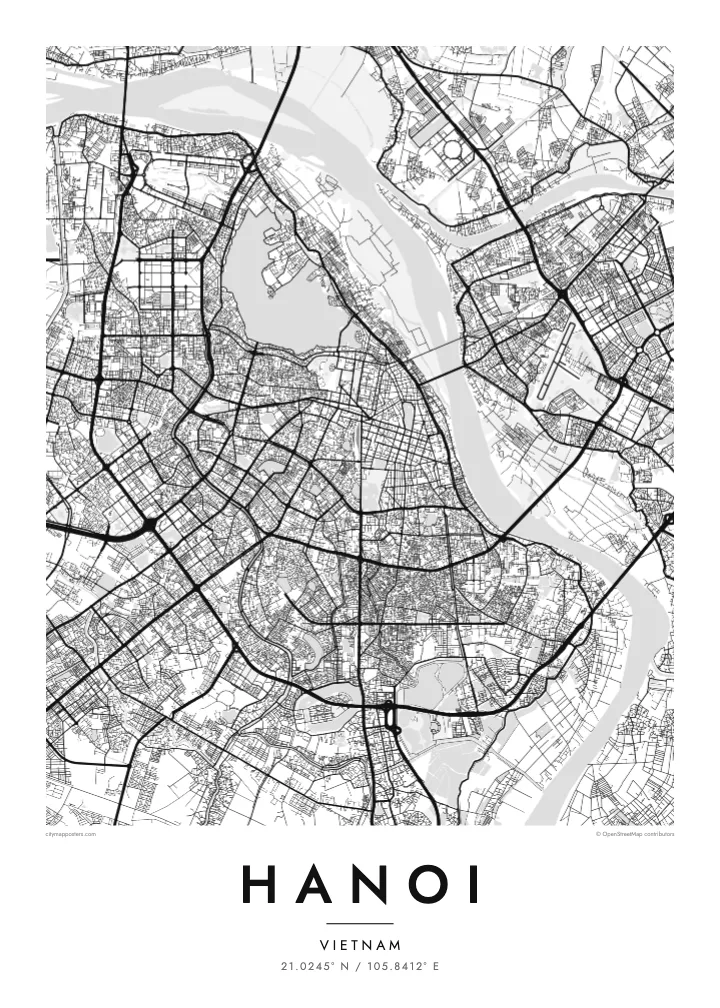
A lake-filled capital on the Red River, where a tight Old Quarter meets French-era boulevards and the broad water of West Lake.


Kolo e tahi, lanu e nima
Tuki he sitaili ke sio ai ʻi te holo. ʻE tatau pē te totogi ʻo te sitaili fuli pē — mokā tā, fakakātoa, peʻe ko he ʻu faila HD.
 Ngaahi pikiseli moʻoni · faila tā 24 × 36″
Mahino lelei ki te pulūti
Ko he konga 100% ʻo te faila tā moʻoni ʻaeni. Ko te ʻu posita fuli pē — mokā tā, fakakātoa peʻe download — ʻe fakatupu ʻi ʻomātou seva ʻi te 300 DPI, aʻu ki te 7,200 × 10,800 pikiseli, koia ʻe nofo mahino ai te ʻu ala liliki ʻi he tā 24 × 36″.
ʻI Te Puipui


Te mapa
Hanoi grew on the right bank of the Red River, named for the reddish silt it carries. The river sweeps along the eastern edge of the central districts behind a long dyke, and the city inside is scattered with lakes. West Lake is the largest, a wide sheet of water in the north, with smaller lakes spread through the older neighbourhoods.
Hoan Kiem Lake lies at the centre of the city, with the Old Quarter packed immediately to its north. That quarter is a dense knot of short, narrow streets, historically organised by trade, many named after the goods once sold there. South of the lake the pattern changes sharply into the wider, more regular streets and villas of the French Quarter, built in the colonial period.
West of the centre, Ba Dinh Square and the Imperial Citadel of Thang Long, a UNESCO World Heritage Site, occupy an area of broad axes and open ground. The Long Bien Bridge, opened in the early twentieth century, still crosses the Red River beside newer spans. A Hanoi map poster captures all of these patterns at once: the river, the lakes and three very different urban grains.
A compact web of narrow streets north of Hoan Kiem Lake, traditionally tied to particular trades and guilds. It is the finest, most intricate texture anywhere on the map.
Hanoi's largest lake, with an irregular shoreline and a small peninsula carrying the Tran Quoc Pagoda. It fills the northern part of the central frame with a single calm shape.
A steel bridge over the Red River, built during the French period and now used mainly by trains, motorbikes and pedestrians. On the poster it is a thin line crossing the wide river and its sandbanks.
Faʻu ke ʻau ʻa ʻau
Tuku he ʻaho, he hingoa peʻe he kiʻi palalau ʻa ʻau, fetogi te faʻahiga, te lahi peʻe te hake.
Ko te faʻata fua noa ʻe māʻulalo hono lelei pea ʻe ʻi ai he fakaʻilonga. Ko te ʻu tā mo te ʻu faila HD ʻe fakatupu ʻi te 300 DPI, aʻu ki te 7,200 × 10,800 px, ʻe mole ʻi ai he fakaʻilonga.
Koteā ko Hanoi
Hanoi leaves a strong impression on residents and visitors alike, from morning exercise around Hoan Kiem to coffee in the Old Quarter. A map of its lakes and streets is a restrained way to keep those memories close, without relying on a single photograph.
Choose a title, add a subtitle such as a date or a street, and adjust the coordinates line. Pick one of five styles; Paper and Sand suit the old city, Noir the river at night. Download the HD files, or order a matte print from partners in more than 30 countries.
Fakatau te posita Hanoi| Lahi ʻo te pulūti | Mahino | Faile |
|---|---|---|
| 30 × 40 cm11.8 × 15.7″ | 3,543 × 4,724 px | PNG · PDF |
| 29.7 × 42 cm (A3)11.7 × 16.5″ | 3,508 × 4,961 px | PNG · PDF |
| 42 × 59.4 cm (A2)16.5 × 23.4″ | 4,961 × 7,016 px | PNG · PDF |
| 45.7 × 61 cm18 × 24″ | 5,400 × 7,200 px | PNG · PDF |
| 50 × 70 cm19.7 × 27.6″ | 5,906 × 8,268 px | PNG · PDF |
| 61 × 91.4 cm24 × 36″ | 7,200 × 10,800 px | PNG · PDF |
Ko te ata ʻe mole totogi ʻe 900 px tona laulahi, mo te fakaʻilonga, ki te sioʻata pē. Ko te ʻu faile HD ʻe aʻu ki te liuga 8 tona mahino, pea ʻe pulūti lelei ʻi te lahi kātoa.
Fili he sitaili ʻi te tuʻa ʻo te pasina, pea fili leva te Posita Tā — he lahi pea, kapau ʻe ke loto ai, he fakakātoa — peʻe ko te ʻu Faila HD Fakakomipiuta. ʻE tahi pē te sitepu ʻo te totogi, pea ʻe fakafou fakavavevave pē tau pasina fakatau mai te taimi ʻe fai ai te totogi.
ʻE tā ʻi he pepa lelei ʻaupito 200 gsm matte, ʻi he tahi ʻo te ono lahi, mai te 30 × 40 cm ki te 24 × 36″. ʻE kamata te ʻu posita tā ʻi te $39, kātoa mo te ʻave.
ʻIo. Fili he fakakātoa ʻakau moʻoni ʻi te kili, hinahina, ʻakau natula peʻe ʻakau ʻuliʻuli. ʻE ʻi ai mo he sioga mālohi ʻe mole mafesi, pea kua teu ke tautau. ʻE kamata te ʻu posita fakakātoa ʻi te $99, kātoa mo te ʻave.
Ko te fakahoko e mole totogi ki te ʼu fenua e 60+. Ko te pōsita taki taha ʼe tā e te tahi ʼo ʼemau ʼu kaufakalogo tā ʼe ofi mai, ʼi te ʼu fenua e 30+, pea ʼe hoko mai ʼi te ʼu ʼaho gaue e 3–7. ʼE feala hau ke ke vakaʼi te tuʼunga mo te tracking ʼi Oku Fakamaʼu. ʼE ʼi ai te ʼu fenua ʼe 2–5 te ʼu vaiaho, pea ʼi te ʼu fenua ʼaē ʼe heʼeki tou fakahoko ki ai, ʼe fakahā e te saite ʼi muʼa ʼo tau totogi.
Fekau mai he ʻata ʻi loto ʻi te ʻaho e 14 talu mai te aʻu mai, pea mātou toe tā noa peʻe toe totogi atu.
ʻIo. ʻI te meʻa fakatonutonu ʻi te pasina ʻaeni, fetogi te kupu tāfito, te kupu lalo pea mo te laina koʻoliteti ki he meʻa fuli pē ʻe ke loto ai, pea fili he sitaili mo he lahi. Ko te ʻu fakatau tā, fakakātoa mo fakakomipiuta ʻe fakaʻaogaʻi katoa pē tou fakatātā.
Mo te $9 ʻe ke maʻu ai te ʻu faila PNG 300 DPI mo PDF kua teu ke tā, ʻi te ono lahi kātoa, ʻe mole ʻi ai he fakaʻilonga, ke ke tā ai ʻi soʻo he potu. Kei tā fakafiafia? Download muʻa he faʻata mokā mo he fakaʻilonga, ʻe fua noa.
