Irrigation ponds
Dozens of small reservoirs sit among the northern neighbourhoods. They are old farming ponds of the Senshu plain and read as quiet, solid shapes inside the street pattern.
Ata mapa faigafua · Japan
34.4833° N / 135.4333° E
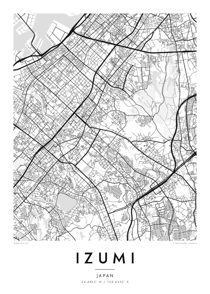
A long inland city climbing from the flat Senshu plain toward the wooded Izumi Mountains on the Wakayama border


Kolo e tahi, lanu e nima
Tuki he sitaili ke sio ai ʻi te holo. ʻE tatau pē te totogi ʻo te sitaili fuli pē — mokā tā, fakakātoa, peʻe ko he ʻu faila HD.
 Ngaahi pikiseli moʻoni · faila tā 24 × 36″
Mahino lelei ki te pulūti
Ko he konga 100% ʻo te faila tā moʻoni ʻaeni. Ko te ʻu posita fuli pē — mokā tā, fakakātoa peʻe download — ʻe fakatupu ʻi ʻomātou seva ʻi te 300 DPI, aʻu ki te 7,200 × 10,800 pikiseli, koia ʻe nofo mahino ai te ʻu ala liliki ʻi he tā 24 × 36″.
ʻI Te Puipui


Te mapa
Izumi stretches across southern Osaka Prefecture in the Senshu area, between Sakai and Kishiwada. It is an inland city, so on a map it runs from the flat plain toward the hills instead of along the bay. The northern districts carry the dense street network of the Osaka suburbs. Further south the lines loosen into valleys, terraced slopes and the forested ridges of the Izumi Mountains, which mark the prefectural border.
Rail shapes the city. The JR Hanwa Line crosses the older western districts, and the Semboku Rapid Railway ends at Izumi-Chūō, near the newer planned housing areas. Across the plain, small irrigation ponds are scattered between neighbourhoods. These reservoirs are typical of the Senshu landscape and appear on the map as neat, rounded shapes set among the streets.
An Izumi map poster covers more than a commuter suburb. The Ikegami-Sone site, one of the best-known Yayoi-period settlements in Japan, lies partly within the city. High in the southern hills stands Sefuku-ji on Mount Makinoo, a stop on the Saigoku Kannon pilgrimage. The Kubosō Memorial Museum of Arts is here too, known for its collection of East Asian art.
Dozens of small reservoirs sit among the northern neighbourhoods. They are old farming ponds of the Senshu plain and read as quiet, solid shapes inside the street pattern.
The Semboku Rapid Railway ends at Izumi-Chūō. Around it, the curving roads and larger blocks of planned residential districts contrast with the older grid to the west.
South of the city, roads narrow into valleys that climb toward the Izumi Mountains. The map opens into wide wooded ground on the way up to Mount Makinoo.
Faʻu ke ʻau ʻa ʻau
Tuku he ʻaho, he hingoa peʻe he kiʻi palalau ʻa ʻau, fetogi te faʻahiga, te lahi peʻe te hake.
Ko te faʻata fua noa ʻe māʻulalo hono lelei pea ʻe ʻi ai he fakaʻilonga. Ko te ʻu tā mo te ʻu faila HD ʻe fakatupu ʻi te 300 DPI, aʻu ki te 7,200 × 10,800 px, ʻe mole ʻi ai he fakaʻilonga.
Koteā ko Izumi
Izumi suits anyone with ties to southern Osaka: a childhood home near the ponds, a daily train from Izumi-Chūō, or a pilgrimage walk up to Makinoo. From above, the city runs from plain to mountain in one long line, which gives the poster a clear direction.
You can edit the title, subtitle and coordinates line to add a street name, a moving-in date or a family name. Then choose one of five styles: Classic black & white, Noir, Paper, Blueprint or Sand.
Fakatau te posita Izumi| Lahi ʻo te pulūti | Mahino | Faile |
|---|---|---|
| 30 × 40 cm11.8 × 15.7″ | 3,543 × 4,724 px | PNG · PDF |
| 29.7 × 42 cm (A3)11.7 × 16.5″ | 3,508 × 4,961 px | PNG · PDF |
| 42 × 59.4 cm (A2)16.5 × 23.4″ | 4,961 × 7,016 px | PNG · PDF |
| 45.7 × 61 cm18 × 24″ | 5,400 × 7,200 px | PNG · PDF |
| 50 × 70 cm19.7 × 27.6″ | 5,906 × 8,268 px | PNG · PDF |
| 61 × 91.4 cm24 × 36″ | 7,200 × 10,800 px | PNG · PDF |
Ko te ata ʻe mole totogi ʻe 900 px tona laulahi, mo te fakaʻilonga, ki te sioʻata pē. Ko te ʻu faile HD ʻe aʻu ki te liuga 8 tona mahino, pea ʻe pulūti lelei ʻi te lahi kātoa.
Fili he sitaili ʻi te tuʻa ʻo te pasina, pea fili leva te Posita Tā — he lahi pea, kapau ʻe ke loto ai, he fakakātoa — peʻe ko te ʻu Faila HD Fakakomipiuta. ʻE tahi pē te sitepu ʻo te totogi, pea ʻe fakafou fakavavevave pē tau pasina fakatau mai te taimi ʻe fai ai te totogi.
ʻE tā ʻi he pepa lelei ʻaupito 200 gsm matte, ʻi he tahi ʻo te ono lahi, mai te 30 × 40 cm ki te 24 × 36″. ʻE kamata te ʻu posita tā ʻi te $39, kātoa mo te ʻave.
ʻIo. Fili he fakakātoa ʻakau moʻoni ʻi te kili, hinahina, ʻakau natula peʻe ʻakau ʻuliʻuli. ʻE ʻi ai mo he sioga mālohi ʻe mole mafesi, pea kua teu ke tautau. ʻE kamata te ʻu posita fakakātoa ʻi te $99, kātoa mo te ʻave.
Ko te fakahoko e mole totogi ki te ʼu fenua e 60+. Ko te pōsita taki taha ʼe tā e te tahi ʼo ʼemau ʼu kaufakalogo tā ʼe ofi mai, ʼi te ʼu fenua e 30+, pea ʼe hoko mai ʼi te ʼu ʼaho gaue e 3–7. ʼE feala hau ke ke vakaʼi te tuʼunga mo te tracking ʼi Oku Fakamaʼu. ʼE ʼi ai te ʼu fenua ʼe 2–5 te ʼu vaiaho, pea ʼi te ʼu fenua ʼaē ʼe heʼeki tou fakahoko ki ai, ʼe fakahā e te saite ʼi muʼa ʼo tau totogi.
Fekau mai he ʻata ʻi loto ʻi te ʻaho e 14 talu mai te aʻu mai, pea mātou toe tā noa peʻe toe totogi atu.
ʻIo. ʻI te meʻa fakatonutonu ʻi te pasina ʻaeni, fetogi te kupu tāfito, te kupu lalo pea mo te laina koʻoliteti ki he meʻa fuli pē ʻe ke loto ai, pea fili he sitaili mo he lahi. Ko te ʻu fakatau tā, fakakātoa mo fakakomipiuta ʻe fakaʻaogaʻi katoa pē tou fakatātā.
Mo te $9 ʻe ke maʻu ai te ʻu faila PNG 300 DPI mo PDF kua teu ke tā, ʻi te ono lahi kātoa, ʻe mole ʻi ai he fakaʻilonga, ke ke tā ai ʻi soʻo he potu. Kei tā fakafiafia? Download muʻa he faʻata mokā mo he fakaʻilonga, ʻe fua noa.
